EEW accuracy analysis
The following tutorial requires pyShake to be installed, see the installation instructions.
Read and Filter EEW solutions
The eew_report2dict function returns a dictionary storing EEW solutions from a file path pattern including EEW reports from SeisComP [sceewlog][sceewlog] and prints the number of solutions.
Then, the reportfilter function filters the EEW solutions based on the specified country code and distance threshold, removing duplicate locations and empty reports, and print the number of filtered solutions. The filtered solutions are stored back in the EEW solutions dictionary.
[sceewlog][https://docs.gempa.de/sed-eew/current/apps/sceewlog.html]
[1]:
countrycode = 'gt'
countryname = 'guatemala'
ref_catalog = ('USGS','us')

from pyshake.catalog import eew_report2dict, reportfilter

# Read EEW solutions
EEWsolutions = eew_report2dict(files='/Users/fred/Documents/Data/ATTAC/alert/insivumeh/example/*txt')
print('%d solutions %d reports'%(sum([len(EEWsolutions[s]['Lon.']) for s in EEWsolutions]),len(EEWsolutions)))

# Filter EEW solutions
EEWsolutions = reportfilter(EEWsolutions,countrycodes=countrycode,dthresh=1.5)
print('%d filtered solutions %d filtered reports'%(sum([len(EEWsolutions[s]['Lon.']) for s in EEWsolutions]),len(EEWsolutions)))
3761 solutions 117 reports
2826 filtered solutions 87 filtered reports
Get reference catalog and Match EEW solutions
The getref function retrieves a reference catalog of seismic events that cover the time-period and the area of the input catalog. The number of reports in EEW solutions and the number of references in reference catalog are printed.
Then, the matchreports function is called with the EEW solutions and reference solutions as arguments to compares the EEW reports with the reference catalog to find matching events. The matching events are determined based on the specified maximum hypocentral distance and origin time difference. The updated EEW solutions dictionary, which now includes the reference source parameters from the matching reference seismic events, is returned by the function and stored back in the EEW solutions variable.
[2]:
from pyshake.catalog import getref, matchreports

# Get  reference catalog
Refsolutions = getref(EEWsolutions)
print('%d reports %d references'%(len(EEWsolutions),len(Refsolutions)))

# Match EEW solutions and reference catalog
EEWsolutions = matchreports(EEWsolutions,Refsolutions)
{'starttime': UTCDateTime(2022, 1, 15, 0, 40, 28), 'endtime': UTCDateTime(2023, 7, 8, 14, 50, 45), 'minlongitude': -94.95, 'maxlongitude': -85.91, 'minlatitude': 11.03, 'maxlatitude': 17.39, 'format': 'csv', 'filename': <_io.BytesIO object at 0x7fb8a8286810>}
87 reports 484 references
Similar origin times
193 reports with matching origin time
Similar origin locations
216 origin loc mismatchs
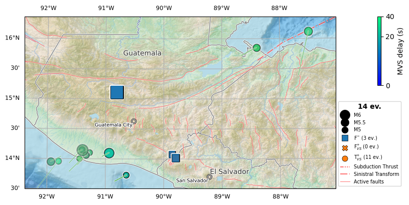
Draw accuracy maps
The map function generates a map of EEW reports and reference seismic events. It also supports all parameters related to the alert_accuracy function from the same module, which is used to classify the EEW reports into true positives, false positives, and false negatives based on the reference seismic events.
The map function is called with the EEW solutions and reference solutions dictionaries as arguments, along with several other parameters. The Mmin parameter is set to 5, as the minimum magnitude of the seismic events to be included in the map. The Lmin parameter is set to 0.4, as the minimum likelihood of the seismic events to be included in the map. The MMImin parameter is set to 4.5, as the minimum Modified Mercalli Intensity (MMI) of the seismic events to be included in the map. The MMIcountry parameter is set to countryname, as the name of the country for which the MMI values are considered. The Mtypes parameter is set to ‘MVS’, as the types of magnitudes to be considered.
The map function returns a Matplotlib axis object, which is stored in the ax variable. This object represents the plot of the EEW solutions and reference seismic events on a map. The map includes the locations of the seismic events, their magnitudes, and their likelihoods. It also includes a legend that indicates the types of magnitudes and the scale of the event sizes.
[3]:
from pyshake.catalog import map
ax = map(EEWsolutions,
        Refsolutions,
        Mmin=5,
        Lmin=0.4,
        MMImin=4.5,
        MMIcountry=countryname,
        Mtypes='MVS',
        )
27/87 F+ and 425/87 F-
/Users/fred/Documents/Projects/SED-EEW/ATTAC/pyShake/docs/../pyshake/util.py:251: ShapelyDeprecationWarning: Setting custom attributes on geometry objects is deprecated, and will raise an AttributeError in Shapely 2.0
  events[e].depth = event[2]
/opt/homebrew/anaconda3/envs/quake/lib/python3.8/site-packages/owslib/map/wms111.py:121: UserWarning: Content metadata for layer "GEBCO_LATEST_SUB_ICE_TOPO" already exists. Using child layer
  warnings.warn('Content metadata for layer "%s" already exists. Using child layer' % cm.id)
/opt/homebrew/anaconda3/envs/quake/lib/python3.8/site-packages/owslib/map/wms111.py:121: UserWarning: Content metadata for layer "GEBCO_LATEST" already exists. Using child layer
  warnings.warn('Content metadata for layer "%s" already exists. Using child layer' % cm.id)
/opt/homebrew/anaconda3/envs/quake/lib/python3.8/site-packages/owslib/map/wms111.py:121: UserWarning: Content metadata for layer "GEBCO_LATEST_2_sub_ice_topo" already exists. Using child layer
  warnings.warn('Content metadata for layer "%s" already exists. Using child layer' % cm.id)
/opt/homebrew/anaconda3/envs/quake/lib/python3.8/site-packages/owslib/map/wms111.py:121: UserWarning: Content metadata for layer "GEBCO_LATEST_2" already exists. Using child layer
  warnings.warn('Content metadata for layer "%s" already exists. Using child layer' % cm.id)
/opt/homebrew/anaconda3/envs/quake/lib/python3.8/site-packages/cartopy/mpl/geoaxes.py:845: UserWarning: Approximating coordinate system <Geographic 2D CRS: +proj=lonlat +datum=WGS84 +ellps=WGS84 +no_defs +t ...>
Name: unknown
Axis Info [ellipsoidal]:
- lon[east]: Longitude (degree)
- lat[north]: Latitude (degree)
Area of Use:
- undefined
Datum: World Geodetic System 1984
- Ellipsoid: WGS 84
- Prime Meridian: Greenwich
 with the PlateCarree projection.
  warnings.warn(f'Approximating coordinate system {crs!r} with '
/opt/homebrew/anaconda3/envs/quake/lib/python3.8/site-packages/cartopy/mpl/style.py:76: UserWarning: facecolor will have no effect as it has been defined as "never".
  warnings.warn('facecolor will have no effect as it has been '
Get event informations
The table function generates a table of false events based on the EEW reports and reference seismic events. It supports all parameters related to the alert_accuracy function (from the same module), which is used to classify the EEW reports into true positives, false positives, and false negatives based on the reference seismic events.
The table function is called with the EEW solutions and reference solutions dictionaries as arguments, along with several other parameters as in the previous map. The table function returns a pandas DataFrame object, which represents the table of false events. The table includes the longitude, latitude, depth, magnitude, origin time, and EEW delay of the false events. The false events are classified into false positives and false negatives. False positives are EEW reports that do not match any reference seismic events, and false negatives are reference seismic events that do not match any EEW reports.
[4]:
from pyshake.catalog import table

table(EEWsolutions,
        Refsolutions,
        Mmin=5,
        Lmin=0.4,
        MMImin=4.5,
        MMIcountry=countryname,
        Mtypes='MVS')
27/87 F+ and 425/87 F-
/Users/fred/Documents/Projects/SED-EEW/ATTAC/pyShake/docs/../pyshake/util.py:251: ShapelyDeprecationWarning: Setting custom attributes on geometry objects is deprecated, and will raise an AttributeError in Shapely 2.0
  events[e].depth = event[2]
[4]:
| Longitude | Latitude | Depth | Magnitude | Origin time | EEW delay | |
|---|---|---|---|---|---|---|
| F- | -90.8052 | 15.1066 | 252.000 | 6.4 | 2023-05-17T23:02:29.919000Z | None |
| F- | -89.8596 | 14.0805 | 7.997 | 5.0 | 2023-01-16T04:47:42.256000Z | None |
| F- | -89.7977 | 14.0226 | 10.000 | 5.2 | 2023-01-15T23:08:23.815000Z | None |